Reading the Sky and Sea: The Science, Storytelling, and Art of Polynesian Wayfinding
By Scott Southworth · August 21, 2026
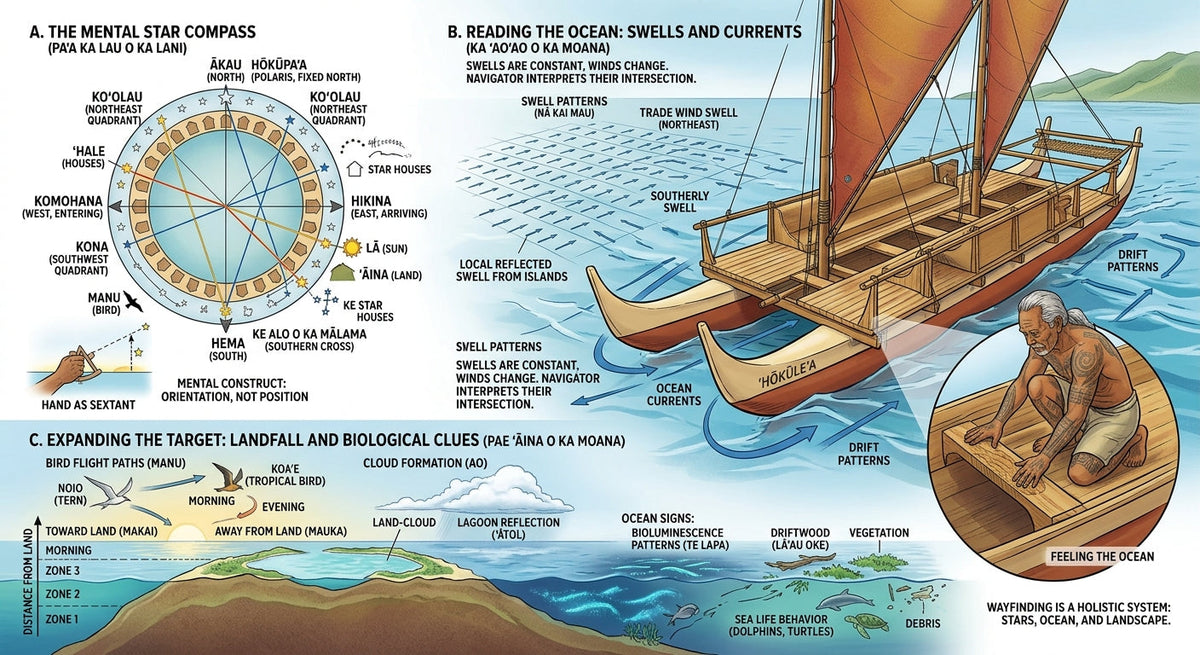
Centuries before European explorers cautiously hugged continental coastlines using magnetic compasses, sextants, and paper charts, Polynesian navigators had already colonized the vast "Polynesian Triangle"—a ten-million-square-mile expanse of the Pacific Ocean anchored by Hawaii, Aotearoa (New Zealand), and Rapa Nui (Easter Island).
They accomplished this astounding feat in double-hulled voyaging canoes (waʻa kaulua), traveling across thousands of miles of featureless open water to locate tiny island specs in a vast ocean.
For generations, Western scholars dismissed Polynesian discovery as "accidental drift"—assuming early voyagers were blown off course by storms. However, modern scientific reconstructions and cultural revivals have proved the opposite: Polynesian wayfinding was a rigorous, highly empirical system of non-instrument navigation that combined astronomy, oceanography, fluid dynamics, and oral storytelling into a unified science.
Part I: The Star Compass (Celestial Mechanics)
The foundation of Polynesian wayfinding is the mental construct known as the Star Compass. Master navigators like Micronesia's Mau Piailug (who famously taught Hawaiian navigator Nainoa Thompson) carried a dynamic, 360-degree mental map of the night sky, dividing the horizon into 32 houses (whare) where celestial bodies rise and set.
                         [ THE STAR COMPASS / KĀPEHU WHETŪ ]
                                    NORTH / ʻAKI
                                         │
                   ┌─────────────────────┼─────────────────────┐
                   │                     │                     │
          West-North-West         House of Stars        East-North-East
                   │                     │                     │
WEST / HIKINA ─────┼─────────────────────┼─────────────────────┼───── EAST / HIKINA
                   │                     │                     │
          West-South-West         House of Winds        East-South-East
                   │                     │                     │
                   └─────────────────────┼─────────────────────┘
                                         │
                                   SOUTH / HEMA
1. Meridian Altitudes and Declination
Unlike a fixed magnetic compass pointing north, the sky is a rotating sphere. Wayfinders memorize the exact points where key stars rise in the east and set in the west.
-
Zenith Stars: Navigators know which stars pass directly overhead (zenith) for specific island targets. For example, Hōkūleʻa (Arcturus) passes directly over the latitude of Hawaii (21°N), while Sirius passes over Tahiti. By sailing until a specific star crosses directly above the canoe's mast, the navigator confirms their latitude without a modern quadrant.
2. Steering by the Horizon
When rising or setting, stars sit on the horizon, providing absolute directional bearings. A navigator lines up the canoe’s bow, stern, or rigging shrouds with specific star houses to maintain a dead-straight course across thousands of miles.
Part II: Oceanography—Reading Swells and Currents
When clouds, rain, or daylight obscure the stars, master navigators shift their sensory focus from the sky to the hull of the canoe. They read the ocean's swells—deep, continuous wave patterns generated by distant storm systems thousands of miles away.
 [ SWELL SYSTEM 1: Trade Winds (NE) ] ──┐
                                       ├──► [ INTERFERENCE PATTERN ] ──► [ CANOE HULL ]
 [ SWELL SYSTEM 2: Antarctic Storms (S) ] ─┘   (Unique Pitch & Roll)     (Navigational Bearing)
1. Tactile Mechanics
Swells are fundamentally different from local wind waves; they are long, consistent, and hold their direction for days. A master navigator lies flat on the deck floor or sits at the stern, feeling the distinct pitch, roll, and yaw of the canoe as it crosses multiple intersecting swell systems.
| Swell Type | Origin & Characteristics | Wayfinding Function |
| Trade Wind Swells | Consistent, medium-length waves generated by persistent northeast/southeast trade winds | Serves as a primary directional baseline during day navigation |
| Southern Ocean Swells | Deep, long-period waves originating from Antarctic low-pressure systems | Provides an immutable south-to-north directional axis |
| Reflected / Refracted Swells | Waves that hit an island and bounce backward into the open ocean | Indicates the presence of land up to 30–50 miles away before it is visible |
When ocean swells hit a hidden island, they bounce back or bend around its landmass. By detecting microscopic changes in wave rhythm—a phenomenon called kaʻele—a navigator senses the invisible "reflection" of land well beyond the horizon.
Part III: Island Expanding (Biological Indicators)
Locating a tiny island in a ten-million-square-mile ocean seems statistically impossible. However, navigators do not aim for a single point of land; they aim for an expanded target spanning 30 to 50 miles wide, using biological and environmental signals.
                            [ THE EXPANDED ISLAND TARGET ]
 ┌──────────────────────────────────────────────────────────────────────────────────┐
 │                                                                                  │
 │                                 [ ATOL / ISLAND ]                                │
 │                                        │                                         │
 │              ┌─────────────────────────┼─────────────────────────┐               │
 │              ▼                         ▼                         ▼               │
 │     [ Cloud Reflections ]      [ Sea Birds Range ]      [ Bioluminescence ]      │
 │    Greenish glow from lagoon   Terns/Boobies fly 30mi   Deep-water "light flashes"│
 │     reflected on cloud base     out to feed at dawn     point toward landmass    │
 │                                                                                  │
 └──────────────────────────────────────────────────────────────────────────────────┘
1. Avian Navigational Vectors
Certain seabirds, such as the manu o Kū (White Tern) and ʻā (Red-Footed Booby), do not sleep on the open ocean. They leave their land roosts at dawn to fly out up to 30 miles to fish, returning to land at dusk.
-
Morning vector: Seeing a White Tern flying straight at dawn indicates land is behind the bird's origin.
-
Evening vector: Seeing a flock returning with fish at sunset provides a direct vector straight to land.
2. Cloud Reflections and Bioluminescence
-
Cloud Base Color: Coral lagoons reflect sunlight upward, casting a distinctive faint greenish hue onto the undersides of high cloud banks.
-
Te Lapa (Deep Lighting): Navigators observe underwater bioluminescent flashes (Te Lapa in the Solomon Islands) that pulse outward from landmasses, acting as underwater lightning streaks pointing toward safety.
Part IV: Storytelling as Data Storage
Without written language, how was this immense volume of astronomical, oceanographic, and meteorological data preserved across centuries? Through moku (oral traditions), oli (chants), and mythological storytelling.
[ COMPLEX SCIENTIFIC DATA ] ──► (Encoded into Myth & Song) ──► [ CENTURIES OF PRESERVATION ]
1. Personification of Astronomical Nodes
In Polynesian culture, stars, winds, and ocean currents were given human names and personalities. Myths detailing the battles or romances between mythical figures were actually mnemonic encoding tools describing spatial relationships between stars or seasonal wind shifts.
Example: A chant describing Maui pulling islands from the sea using a giant fishhook is a literal navigational narrative centered on the constellation Scorpius (known as Manaiakalani or Maui’s Fishhook). When the constellation rises high in the night sky, it signals the exact latitude and seasonal window for voyaging between specific island groups.
2. The Star Path (Kāinga)
Navigators memorized long lists of stars called Pae Māhana (Star Paths). Taught to young initiates inside sacred schools (hale nauā) using physical pebble-and-leaf diagrams laid out on woven mats, these songs allowed navigators to mentally play back entire trans-oceanic routes through verse.
The Modern Renaissance of Wayfinding
By the mid-20th century, Westernization and steamships had almost completely wiped out non-instrument navigation across Polynesia. By the 1970s, only a handful of elders—most notably Mau Piailug from the small Micronesian atoll of Satawal—retained the full knowledge of the Star Compass.
In 1976, Mau Piailug agreed to break traditional secrecy to teach a new generation of Hawaiians. Together with the Polynesian Voyaging Society, they built Hōkūleʻa, a traditional double-hulled voyaging canoe, and successfully navigated from Hawaii to Tahiti using zero instruments—proving to the world that their ancestors were the greatest open-ocean navigators in human history.
Today, wayfinding is not merely a historic relic; it is a vibrant, expanding science that blends deep environmental awareness with human endurance—proving that when you know how to read the natural world, the ocean does not divide humanity; it connects us all.